
Abuja, Explained: A Visitor’s Map & Area Guide
- pideh2
- Oct 4, 2025
- 2 min read
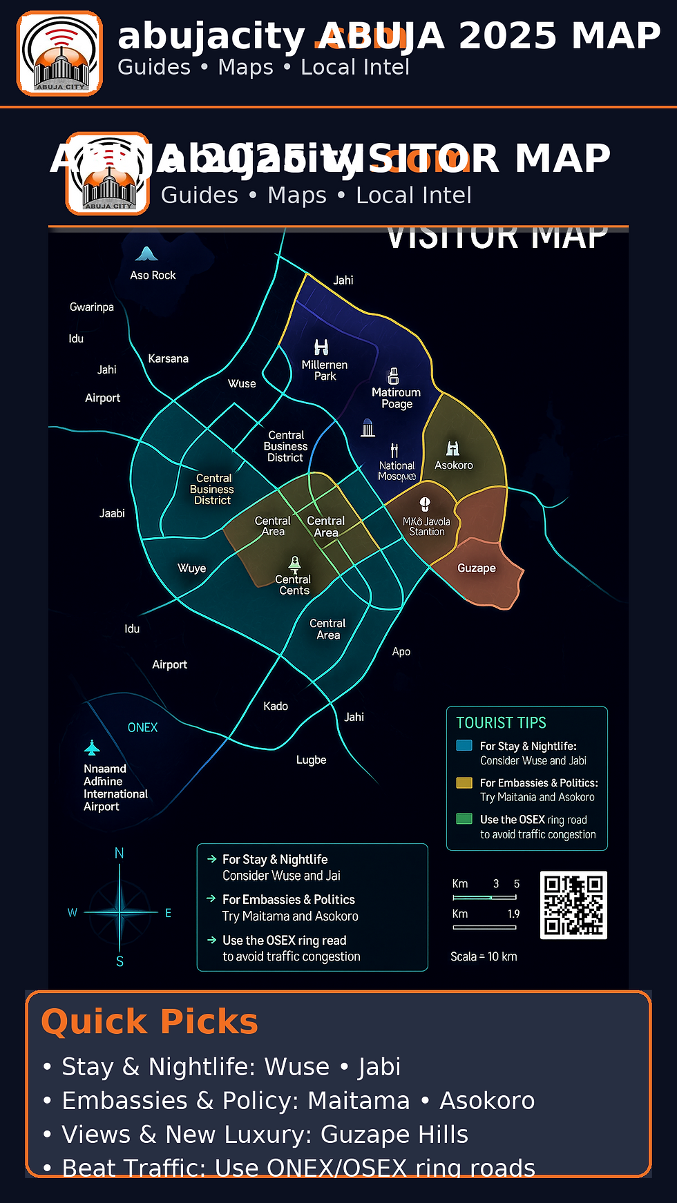
Abuja was designed as a planned capital with ring roads, wide boulevards, and distinct districts. Think of the city in six practical zones for visitors: Business/Central, Embassy & Diplomatic, Lively & Social, Established Residential, Growth Corridors, and Logistics & Gateways. Use the map legend to match colors to zones and pick your base.
1) Business & Central Core
Central Business District (CBD) • Central Area
Why stay: Closest to ministries, conferences, Eagle Square, National Assembly, and major hotels. Shortest transfers for meetings.
Landmarks: National Mosque, National Christian Centre, Millennium Park, Central Bank area, high-rise offices.
Vibe: Weekdays busy, nights quieter. Great for time-pressed trips.
2) Embassy & Diplomatic Belt
Maitama • Asokoro • Guzape (hillside)
Why stay: Embassies, government residences, and upscale homes. Clean, secure, leafy.
Vibe: Calm, polished; restaurants are refined rather than rowdy.
Good for: Delegations, VIP visits, wellness retreats on hilly streets with views of Aso Rock.
3) Lively & Social Grid
Wuse (Zones 1–7 & Wuse 2) • Jabi • Utako • Wuye
Why stay: Dining, lounges, malls and markets. Quick access to the CBD without losing nightlife.
Highlights: Wuse Market for souvenirs; Jabi Lake for waterside dining and weekend events; Utako Motor Park (intercity buses).
Tip: Expect traffic spikes around after-work hours.
4) Established Residential & Long-Stay
Gwarinpa • Life Camp • Jahi • Katampe • Mabushi • Kado
Why stay: Space and value for longer trips; good Airbnbs and serviced apartments.
Vibe: Local cafés, neighborhood gyms, quieter evenings.
Tip: Pick places near major arteries (e.g., Nnamdi Azikiwe/ONEX) for smoother commutes.
5) Growth Corridors (Good Value)
Apo • Durumi • Gudu • Lokogoma • Galadimawa • Kaura
Why stay: Rapid development, modern apartments, better value than inner districts.
Vibe: Emerging dining scenes, weekend brunch spots; roads improving year by year.
Tip: Plan extra travel time at rush hour.
6) Logistics & Gateways
Airport Road/Lugbe • Idu Rail & Industrial Area
Why stay: Convenient for late-night/early-morning flights or onward travel.
Notes: Nnamdi Azikiwe International Airport sits west of the city; Idu hosts the standard-gauge rail to Kaduna and industrial estates. Always check current rail/light-rail service status.
Picking the Right Base (Fast Recommendations)
48-hour business dash: CBD or Central Area.
Embassy, policy, or ultra-quiet: Maitama or Asokoro.
Food, lounges, and social energy: Wuse 2 or Jabi.
Family or remote-work month: Gwarinpa, Jahi, Katampe, or Life Camp.
Airport convenience on a budget: Lugbe corridor.
Views & new luxury builds: Guzape hills.
Getting Around Smartly
Rideshare first: Bolt/Uber are widely used; hotels can arrange cars with drivers.
Road rhythm: Peak times ~7–9am and 4:30–7:30pm. Use ONEX/OSEX ring roads to skirt central congestion.
Orientation markers: Aso Rock (north-east skyline anchor), Jabi Lake (north-west leisure anchor), and the Airport (far west).
Etiquette & safety: Seatbelts, modest speed, avoid photographing sensitive government facilities, carry an ID, and keep devices charged.
How to Use the Map
Colors = purpose:
Gold = Business/Central
Slate/Green = Embassy & Diplomatic
Teal/Blue = Lively & Social
Indigo = Established Residential
Orange = Growth Corridors
Cyan outline + icons = Logistics & Gateways (Airport, Rail)
Icons: Airport ✈︎, Rail ⦿, Worship sites, Parks, and Stadium are marked for quick bearings.
Callouts: “Tourist Tips” panel highlights best areas by trip style and reminds you to use ring roads.


Comments